From Ars Technica: Verizon’s shared data plans won’t save solo users much money

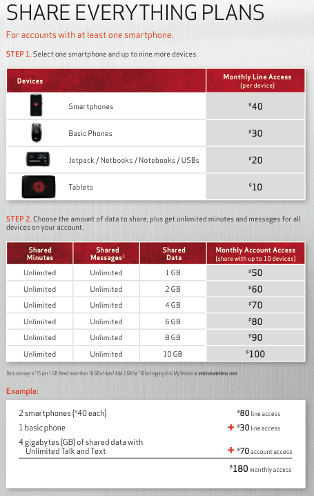
Verizon’s shared data plans will finally be available to customers starting June 28. Well, not exactly shared data plans—plans that share everything, including data, unlimited texts, and unlimited voice minutes. Currently, there’s no way to get shared data without an otherwise fully unlimited plan.

Verizon and AT&T have been promising shared data on family plans for some time, saying it was a logical evolution of the way phone plans have been offered. Verizon’s new plan charges an “account access” rate based on the size of the shared data bucket, and then a separate fee per device that uses the plan. The least expensive access fee is $10 per tablet, going up to $40 per smartphone. Plans start at $50 to share 1GB, up to $100 for 10GB.

The breakdown of the charges for Verizon’s “share everything” plan.

While families may have endless permutations of device combinations, one of the use cases we expected to be alleviated by shared plans is that of a single user with a smartphone and tablet. Previously, such a person would have had to buy separate data plans for each device.


from Ars Technica

From Ars Technica: Using LiDAR, filmmaker discovers “lost city”

Cinematographer Steve Elkins announced last week that by using LiDAR (light detection and ranging), he discovered “what appears to be evidence of archaeological ruins in an area long rumored to contain the legendary lost city of Ciudad Blanca.” The phrasing “lost city” is problematic, however: it’s hard to lose a city when the city itself is a myth.

The mapping project, conducted over 40 hours split between seven flights during April and May, was led by Elkins’ group, UTL Scientific. Participants include the thriller writer Douglas Preston, who is the former editor at the American Museum of Natural History. The project took place in conjunction with the government of Honduras with the help of technicians from the National Science Foundation’s National Center for Airborne Laser Mapping and professors from the University of Houston.

The tech

The LiDAR survey covered the history-rich northeastern Mosquitia region of Honduras. They overflew the area, sending “25 to 50 laser pulses per square meter—a total of more than four billion laser shots” to the ground, according to the University of Houston, and capturing differences in elevation of as little as four inches. This process can look underneath forest canopies, producing a 3D map of areas in hours or days that an overland, machete-hacking expedition might take years to do.


from Ars Technica